   
|
最新消息 News
簡介 About Dongsha Atoll Research Station-Marine Station in north South China Sea
.png)
東沙環礁地處南中國海(簡稱南海)北部,與最近的陸塊距離超過250 公里,與高雄港距離超過400 公里,遺世獨立,其特殊的地理環境造就了值得深入探討的科學議題相當廣泛,其多元的環境簡述如下:
- 1. 南海是全球最酸的海洋,pH值約比全球低0.1(過去200年全球pH值約降0.1)
- 2. 北南海是全球最大規模內波(internal waves)的發生處
- 3. 東沙環礁的海洋生態主要為珊瑚礁生態系,雖受到人為漁撈的威脅,但其主要的威脅多半是全球大尺度的環境變遷所造成
- 4. 東沙環礁經常遭受颱風的侵襲,由西太平洋或南海起源的颱風都可能經過東沙
- 5. 東沙環礁兼具大洋與島嶼的生態尺度,生物多樣性豐富,各大類群生物的物種組成、分佈、資源皆具有代表性
對於希望聚焦在上述自然環境變化的研究人員,東沙國際海洋研究站以地利之便的優勢,可克服過去研究上所遇到的障礙,提供研究人員在後勤的補給,協助研究人員能迅速掌握地理、環境的特性,創造突破的先機,有效的由小東沙觀大地球。?nbsp;本研究站亦歡迎請國際專家登島,配合國內的學者參與東沙環礁物種多樣性研究。
研究方式主要以研究站、研究船進行。環礁本身水深分佈複雜,從 0~15 公尺左右的潟湖以及 0~2 公尺深的礁台(視潮水漲落而定) 乃至 3 公尺以下的礁坡,其範圍涵蓋約 5~6 百平方公里,主要以研究站之小艇作業。
Dongsha Atoll locates on the northern part of the South China Sea. The shortest distance to mainland of the remote atoll is over 250km, and is over 400km to Kaohsiung, Taiwan. Dongsha Atoll is a place with various scientific interests because of the unique geographical environments: :
- 1. A fast acidified ocean (Liu et al., 2013). The pH value is 0.1 lower than other oceans (the pH value is decreasing 0.1 in the past 200 years in world oceans)
- 2. The strongest internal waves (IWs) that are generated by intrusions of the Kuroshio Current into the Luzon Strait pass by Dongsha area.
- 3. With remote and independent coral reef and seagrass ecosystems. The ecosystems are mostly influenced by global changes and with very few anthropogenic effects.
- 4. Typhoons often pass through Dongsha area.
- 5. Dongsha Atoll encompasses both oceanic and island ecosystems, and with high biodiversities.
The Dongsha Atoll Research Station (DARS), founded in 2012, is located on Dongsha Island; it provides variety of research facilities to visiting scientists. DARS is like a boat staying in the South China Sea; it will continuously serve to promote researches resolving the scientific questions relating to atoll and South China Sea. In addition to assist the on-going studies, further international co-operations are welcome to be conducted at Dongsha Atoll Research Station. Accommodations and vessels that suitable for various destinations on Dongsha Atoll are ready for researches. R/V Atoll I, Atoll II (since 2014), Atoll V and Atoll VI (2016) are equipped for different destinations on Dongsha Atoll and nearby areas. R/V Atoll I and Atoll V are convenient for operating at reef crest, but with smaller space and capacity. R/V Atoll II and Atoll VI are able to travel around fore-reefs, and the waterline of Atoll VI is 40 cm that makes this boat easy to travel in the lagoon and shallow patch reefs. Kayak and dinghy are also available for trips in Dongsha Island small lagoon.
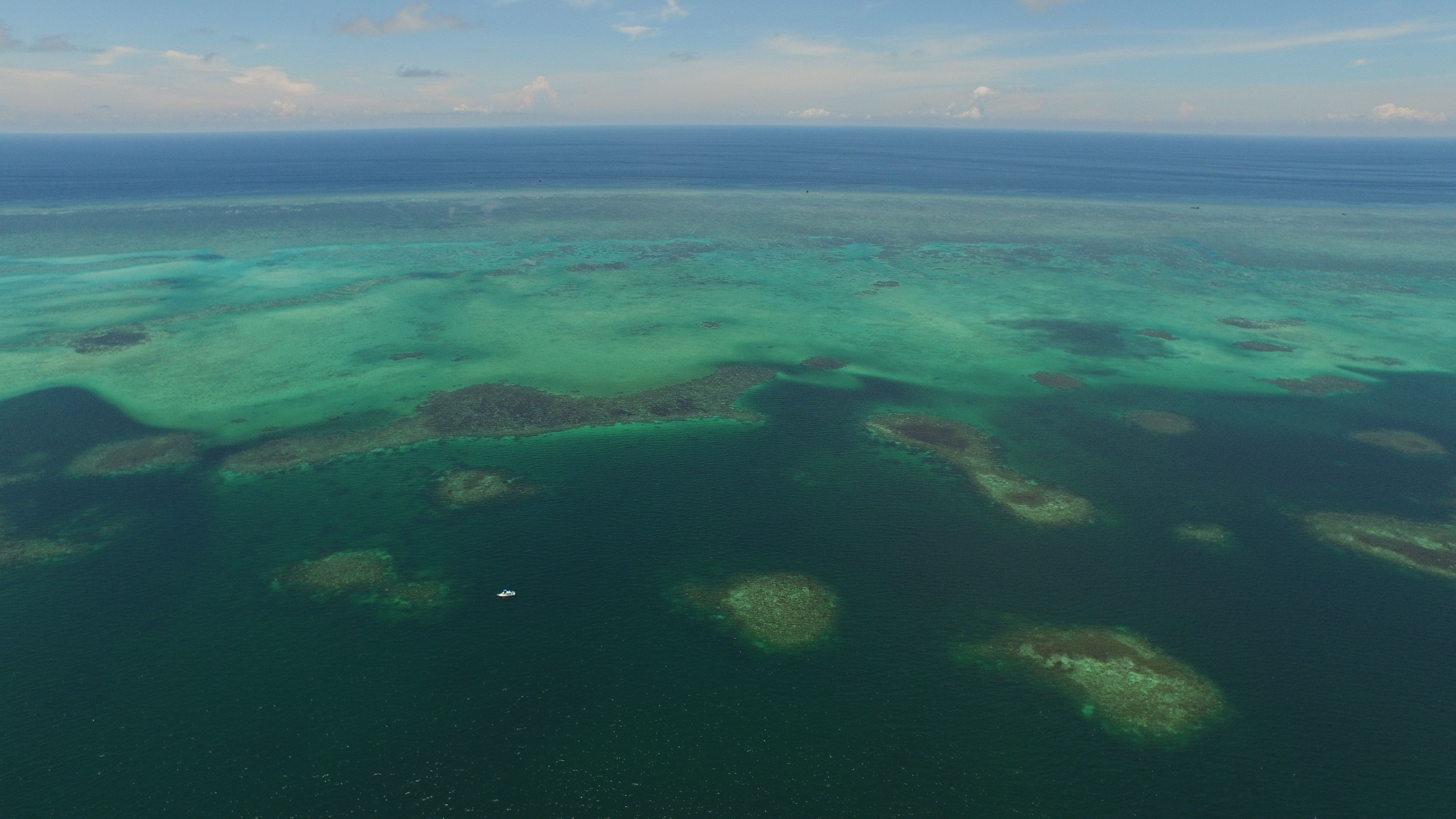
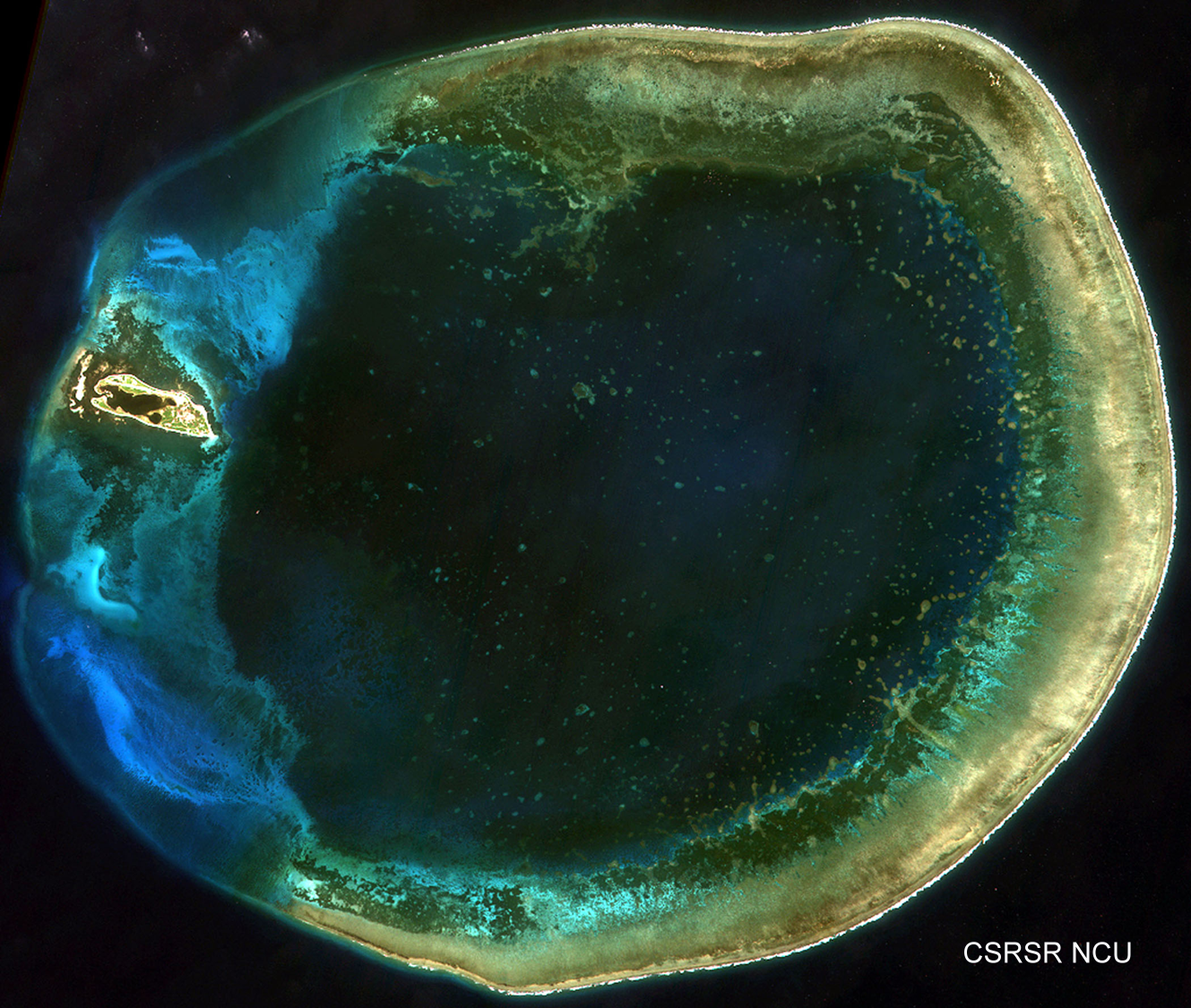
The Atoll is composed of three parts including fore-reefs, back reefs and lagoon that can easily be identified from satellite imagery
Fore-reefs
The fore-reefs on Dongsha Atoll is defined from the edge of reef crest toward reef slope, and its well-developed spur-and grooves structure could be seen from aero photos. Reef slope extended smoothly to the water depth of 25m at a horizontal distance about 1 km from shore. Reef cliffs usually appear below the water depth of 25m, and extend to deeper ocean basin.
Atoll lagoon
In Dongsha lagoon, the most eye-catching features are the patchy reefs. From satellite imagery and drone photos, hundreds of patch reefs distributed in the lagoon with variety depths and diameters of reef tops. (photo credit: Yu-ming, Chang)
Reef crest
The reef crest could be roughly separated into 2 parts of shallow outer reef crest and seagrass beds in inner crest (Kao et al. 2013). The outer reef crest is around 1-2 km in width from the edge of the fore-reef toward lagoon with water depth of 1-2 m and may expose to air when in spring tides. Satellite imagery and ground truth data provide practical information for reef crest on Dongsha Atoll. The reef crest could be roughly separated into 2 parts of shallow outer reef crest and seagrass beds in inner crest (Kao et al. 2013). The outer reef crest is around 1-2 km in width from the edge of the fore-reef toward lagoon with water depth of 1-2 m and may expose to air when in spring tides. Seagrasses are mainly composed by three species on the whole reef crest: Thalassia hemprichii, Cymodocea serrulata and Cymodocea rotundata; and at least three other species have been observed around Dongsha Island in restricted areas: Halodule univervis, Halodule ovalis and Syringdodium isoetifolium. The satellite imagery taken from 1994 to 2016 indicates a mass seagrass die-off in recent years (Ren et al. 2014).
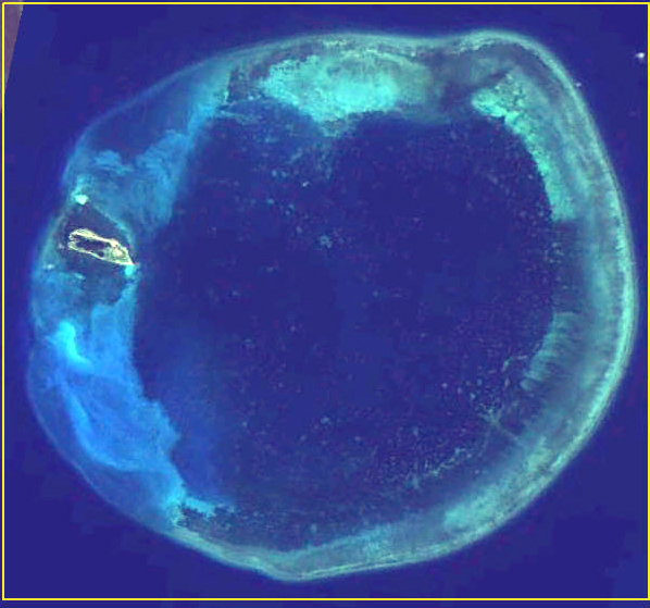
Left : before die-off; Right: July, 2015 (white patches at north, northeast and southeast arcs indicate seagrass die-off areas)
More underwater videos could be found under "Multimedia: The Atoll that you don't see"
東沙國際海洋研究站,將進行研究主軸:
Research Focuses-Dongsha Observation of Coral Reef and Oceanography (DOCO):
DOCO-Time Series
為建立東沙環礁海水基本資料,除持續海水溫度的量測外,每周一次在三個測點(兩個潟湖內、一個北航道口) ,量測pH,螢光度、鹽度、採海水(測CO2、營養鹽)、動物性浮游生物。
1. Continuous water temperature monitoring around Dongsha Island
2. Water temperature, salinity, pH value, chlorophyll a, turbidity, DO, water sampling (CO2, nutrients) and zooplankton at three fixed sampling sites
DOCO-Spatial Pattern
為了解環礁底棲生物, 在環礁礁坡、礁台及潟湖採取沈積物表面生物(如有孔蟲)。
Continuous sampling of the benthic organisms in sediments, e.g. foramanifera, in reef slope, reef plat and atoll lagoon.
DOCO-Conservation
從海洋國家公園保育、復育觀點,選擇重要物種,與澎湖縣政府農業局水產種苗繁殖中心合作,進行幼貝、幼株繁殖、放流試驗。
The key species such as corals or bivalves were chosen with Marine National Park conservation policy. The reproduction and release studies co-operate with Penghu county marine life propagation station.
DOCO-(Soft) Coral Survey
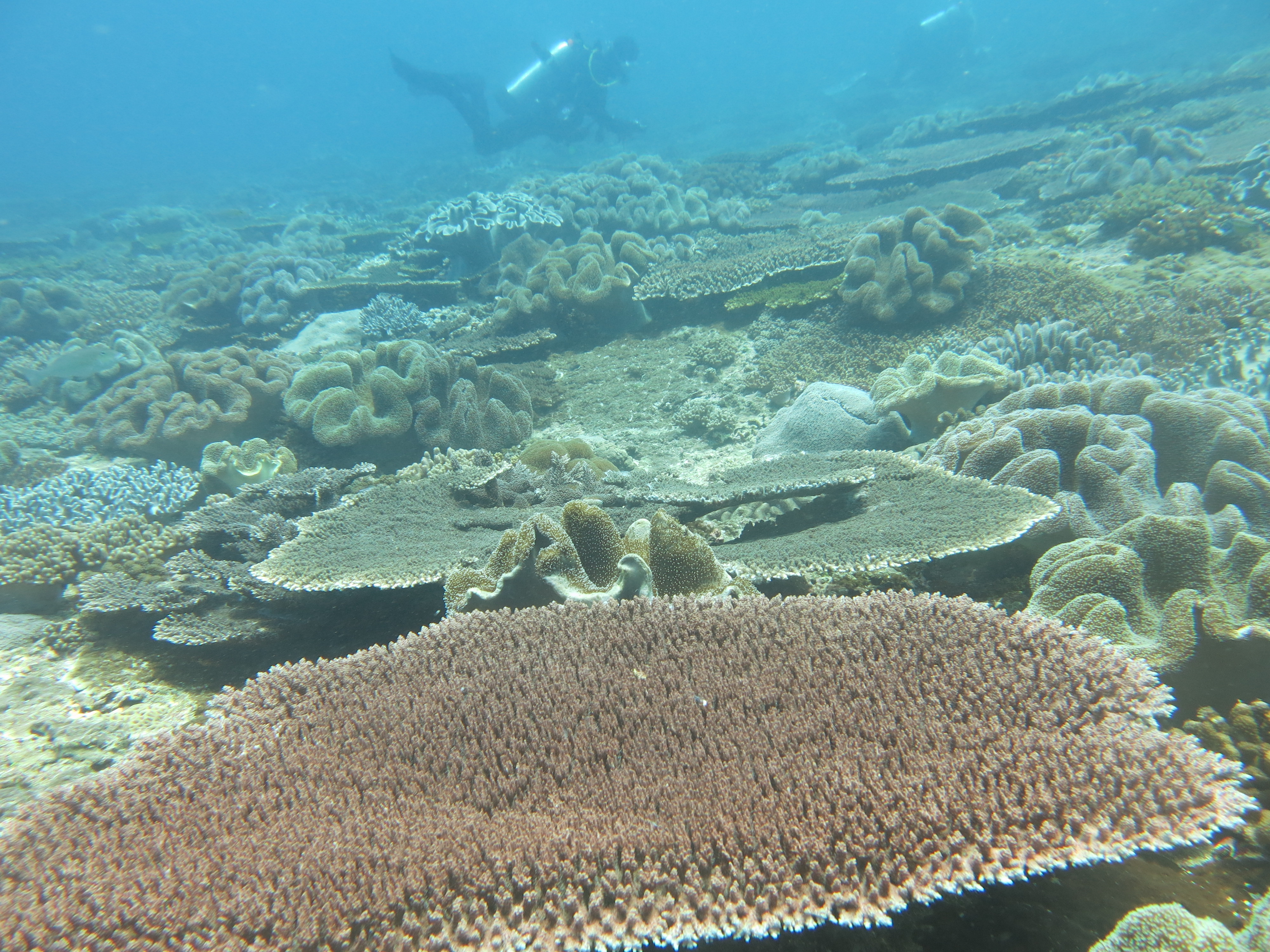
為了解環礁礁坡底棲生物組成,在東、南、西、北各選三樣點,由5公尺深度至25公尺共三至五個等深測線,以潛水錄影方式紀錄。在礁台淺水域不適船舶棲所,以衛星影像、遙控直昇機配合潛水調查人員地真工作進行。瀉湖內則以塊礁為單位,進行五點的永久測線紀錄。
To understand the benthic communities in reef slopes, 3-5 transects along the sea contours from 5-25 water depth are recorded by video. Three observation sites are recorded at eastern, southern, western and northern atoll respectively. In the shallow reef plats, satellites, UAVs and ground truthing are employed. There are 5 fixed observing sites in patch reefs in the atoll lagoon.
DOCO-International
為促進國內及國際科研人員利用本站資源進行環礁、海洋、自然之研究及探索, 本站積極連絡、邀請潛力及相關科學家。有興趣者可先上本站網站 (關鍵詞: 東沙國際海洋研究站)或參考DARS.ppt
DARS welcomes international co-operation researches in Dongsha Atoll. The contacts are listed below and the detail information about DARS can be found in this site or DARS.ppt
有興趣參與上述研究或新提構想者, 請連絡本計晝主持人或共同主持人 Contacts
|
PI |
|
|
|
|
廖德裕 |
Te-Yu Liao |
國立中山大學NSYSU |
tyliao@mail.nsysu.edu.tw |
| Co-PIs | |||
|
宋克義 |
Keryea Soong |
國立中山大學NSYSU |
keryea@mail.nsysu.edu.tw |
|
林博雄 |
Po-Hsiung Lin |
國立台灣大學NTU |
polin@ntu.edu.tw |
|
廖志中 |
Chih-Chuang Liaw |
國立中山大學NSYSU |
ccliaw@mail.nsysu.edu.tw |
|
劉莉蓮 |
Li-Lian Liu |
國立中山大學NSYSU |
lilian@mail.nsysu.edu.tw |
尚待推動工作 Further works in DARS
DOCO-Sipunculate、DOCO-Drill、DOCO-Recruitment


