

海洋物理 Marine Physics
簡介:東沙環礁的海洋物理環境
(王玉懷、李逸環,國立中山大學海洋科學系)
東沙環礁東沙環礁直徑約25公里,面積500平方公里。環礁底部座落於南海北部大陸斜坡,水深約300-400公尺的台階上。環狀礁台區長約46公里、寬約2公里(圖1)。環礁的西北及西南有天然缺口,形成南、北水道,是進入內環礁水域的主要通道。東沙島周圍的水深約2至5公尺,南北航道水深約5至8公尺,環礁內水深約10至15公尺,最深可達22公尺(圖1),等深線分布如同心圓般,外圍較淺而中間較深,呈漏斗狀,其水深分布與珊瑚礁之生成有關。
The Dongsha Atoll is around 25 km in diameter, and 500 km2 in coverage of the atoll is around. The atoll located on the continental slope in northern part of South China Sea, and the depth of atoll base is around 300-400 meter from water surface. Ring-like reef flat is approximately 46 km long and 2 km in width (Fig 1). The reef of atoll ring may expose to air while ebb tides. Dongsha Island locates on the eastern part of the atoll and is the only part that higher than sea level. There are Northern and Southern Channels at northern and southern sides of Dongsha Island, respectively. Water depth near Dongsha Island are around 2-5 m, and both of the channels are 5-8 m in depth which are the main pathways for water masses. The water depth in atoll lagoon is 10-15 m, with the deepest part of 22 m (Fig 1). Lagoon base is funnel shape, and the water depths in atoll lagoon relate to coral distributions.
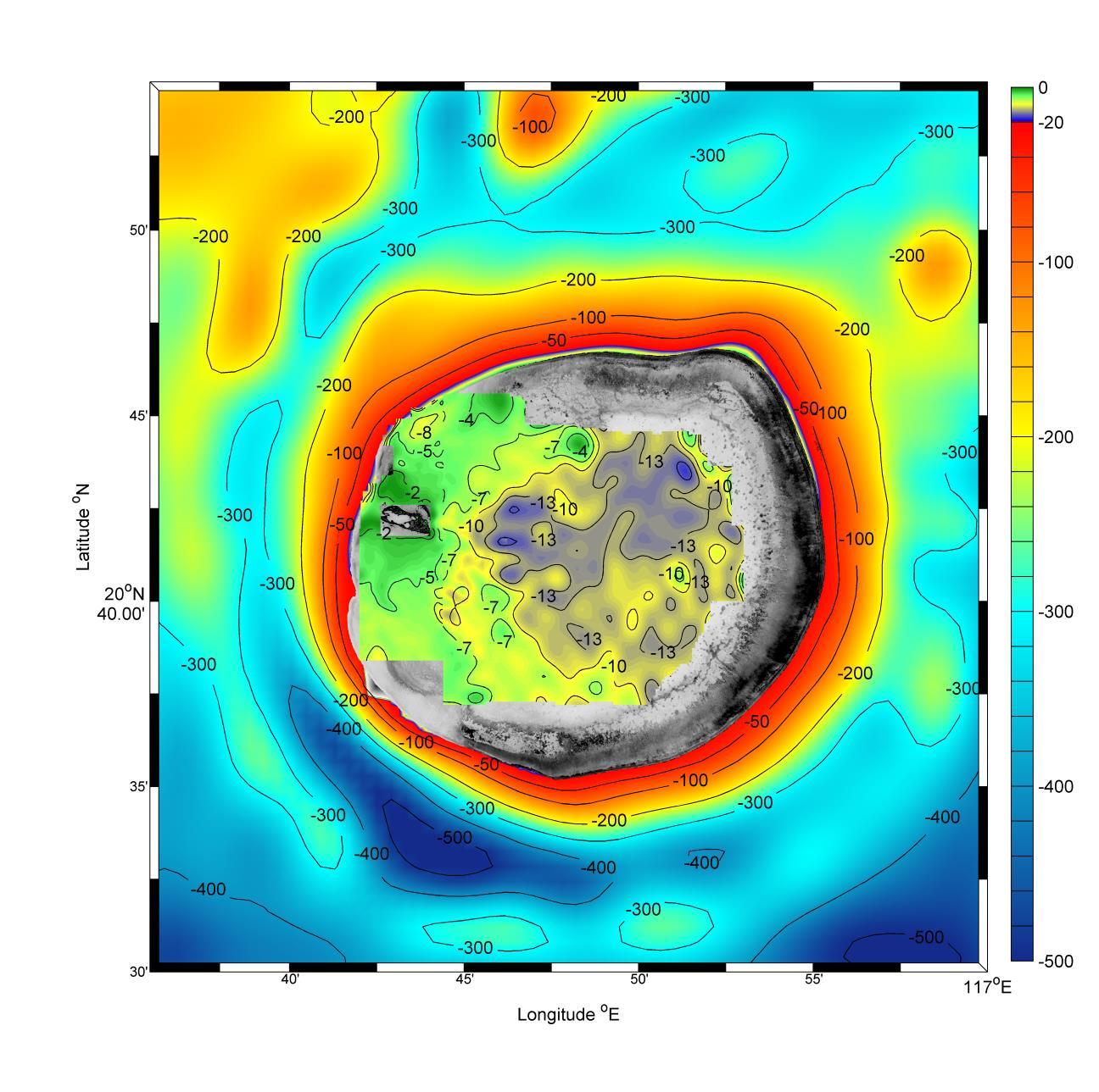
圖1. 東沙環礁水深地形圖(資料來源:王玉懷實驗室及海洋國家公園管理處)。
棲地分布主要以珊瑚礁為主體,珊瑚及珊瑚殘骸遍佈整個內環礁,1998年聖嬰現象造成的海水升溫,以及人為破壞,導致環礁內珊瑚白化情況相當嚴重,大部分珊瑚礁區皆為珊瑚殘骸。海藻、海草主要生長在東沙島周邊,內環礁東北淺水處也偶爾可見海藻、海草的分布。沙質海底主要分布於內環礁西南側,環礁中間偶爾也可見到小片沙地。礁石海底以北航道及內環礁南側較常見。早年內環礁珊瑚覆蓋茂密,近年觀察在水深較深處有些活珊瑚(圖2)。據戴昌鳳(2006)研究報告指出,東沙環礁外圍水深0~25 m之間屬於礁斜坡區,寬約數百公尺,其中水深0~15 m的坡度平緩,水深15~25 m以深則為陡坡。環礁外圍的珊瑚群聚則屬於良好狀態(圖3),主要分布在水深0~15 m的礁斜坡區,平均珊瑚覆蓋率在75~85%。環礁內部潟湖區水深5 m以淺的底質主要由珊瑚殘骸組成,活珊瑚覆蓋率極低(<5%);水深5~10m的珊瑚覆蓋率稍高,約10%,以團塊形的微孔珊瑚及菊珊瑚群體為主;水深10 m以深,則以蕈珊瑚和葉片形珊瑚為優勢物種,珊瑚覆蓋率約15-20%。
Habitats The substratum in Dongsha are mainly composed of coral reefs. However, the El Niño event in 1998 caused a mass coral bleaching and death, thus the substratum in atoll lagoon are mostly dead reefs now. Sea grass beds are distributed on the atoll flats especially around the Dongsha Island. The southwest part of the atoll are mostly sandy areas, and fragmentary sandy substratum are also observed in center of the atoll (Fig 2). The northern channel and southern part of the atoll are composed by reefs. Meanwhile, the patchy reefs are also distributed in the atoll lagoon. The fore reefs of Dongsha Atoll are reef slopes with water depth of 0-25m, and the width are hundreds of meters (Fig 3). The slopes are smooth from 0 to 15m, and become steep slopes in 15-25m. Living coral cover ranged from 75% to 85% among the 0-15m reef slopes. In atoll lagoon, the substratum are mostly composed by coral pebbles within 5 m water depth and with low living coral coverage (<5%); in the water depth of 5-10m, the living corals are composed of Porites spp. and Favites spp. with the coverage of around 10%; below 10m, the coral coverage is around 15-20% and mainly composed of Fungia spp. and Montipora spp.
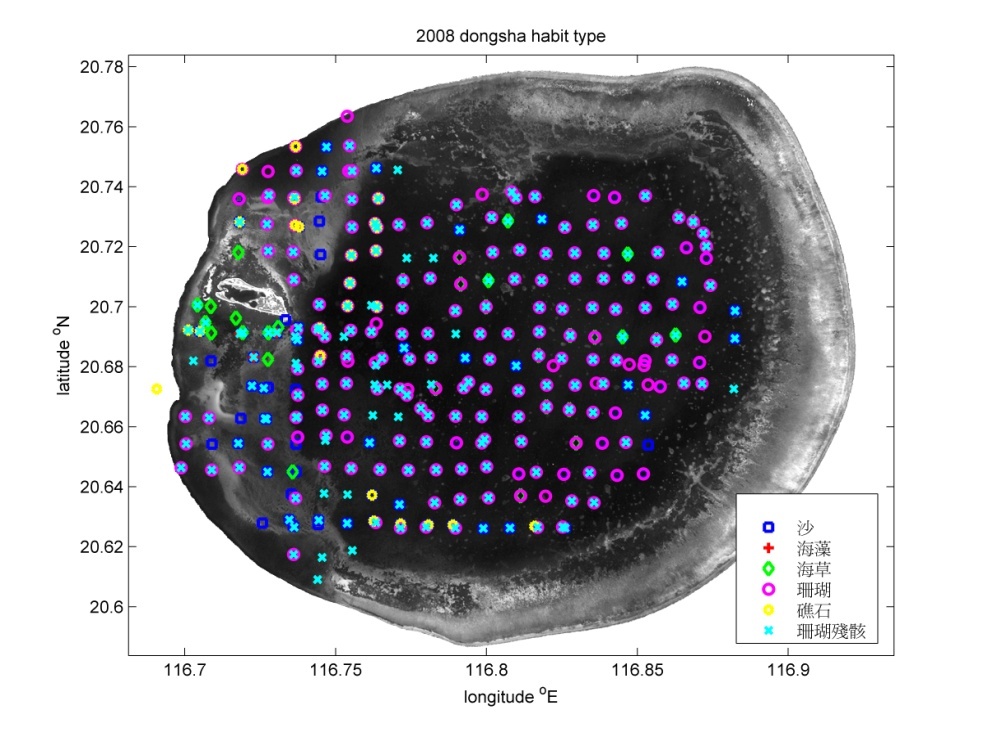
圖 2. 東沙內環礁棲地分布圖(資料來源: 王玉懷實驗室及海洋國家公園管理處)。
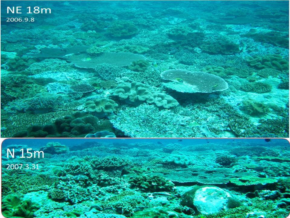
圖3. 東沙環礁外緣棲地之照片,上圖攝於東北角水深18米,下圖攝於北側水深15米。資料來源: 王玉懷實驗室)
氣候 變化上因為東沙島小且四面環海,島上無顯著之凹凸地形,故全島變化一致。由近年之東沙島觀測之氣象資料(圖4),東沙地區1至4月及10至12月主要為東北季風,5至9月為西南季風,但6至8月受到颱風侵襲影響則風向變化較大,颱風最大風速可超過30 m/s。全年的氣溫變化在15.8到35.5 ℃間,平均溫度為26 ℃。夏季較熱,5~9月平均溫度在28℃左右,以7至8月氣溫最高,但如有颱風影響則溫度可下降2~3℃。冬季以1月最冷,12~3月平均溫度在23℃左右,溫度變化主要受到東北季風的鋒面影響,變化的幅度取決於鋒面的強度,約在2~4℃。日平均氣壓變化為966到1027毫巴,年平均氣壓1010毫巴。東沙緯度較台灣低,平均氣壓略高可能是溫暖海水使水氣充足所致,氣壓在冬季高壓鋒面來臨時有3至10天的高值,夏季颱風來臨則有低壓的極值。
Climate The Occasional Monsoons occurred from October to April in Dongsha area (Fig. 4), and the southwest monsoons occurred from May to September. The strongest wind speed could be over 30 m/s when typhoons passing through from June to August. The air temperature ranged from 15.8 to 35.5˚C, and the yearly average is 26˚C. The average temperature from May to September is 28˚C, the highest temperature usually occurred in July or August and may decrease 2-3˚C when typhoons passing through the Dongsha atoll. The lowest temperature occurred in January, and the average temperature from December to March is 23˚C. The temperature may drop 2-4˚C when Occasional Monsoons arrive this area. The daily atmosphere pressure ranged from 966 to 1027 mb, and yearly average is 1010 mb. The atmosphere pressure in Dongsha is higher than in Taiwan which may due to the adequate water vapor in low latitude. When the Occasional Monsoons arrive Dongsha area, 3-10 days high pressure are recorded. On the other hand, the lowest pressure are found when typhoons passing through this area.

圖4. 東沙島2006~2009年觀測風速、風向、氣溫、氣壓之日平均圖。
水溫變化主要受到季節、日照、潮汐及南海內波的影響。東沙環礁內與環礁外(2006年7月至2010年9月)之水溫變化範圍為17 ℃~32 ℃(圖5),平均溫度約為26.4 ℃(與平均氣溫相仿),內環礁水溫高於外環礁水溫,小潟湖內因強烈日照以及幾乎沒有流動的淺水所致,曾觀測到瞬間最高水溫為38.3 ℃。夏季7至8月水溫最高,水溫也受颱風影響而變化。冬季水溫1月最冷,東北季風鋒面影響下也會造成水溫明顯下降。環礁內水溫日變化約1至2 ℃,主要受日照及潮流所影響。南北航道水溫日變化2至4 ℃,比內環礁變化大一倍,顯然是受到潮流帶來的環礁外冷水團所影響。環礁外(東北角)觀測到的水溫,普遍比內環礁低,原因是呂宋海峽產生的內波,向西經南海傳播至東沙環礁,地形淺化將底層較冷海水帶至淺水區,水溫常見到3 ℃至9 ℃的陡降,在內波來襲時,有3~6小時的一波波冷水。水溫調和分析相位顯示,冷水由環礁外經南北航道,向環礁內傳遞擴散。冬季時,內環礁水溫較外環礁冷,因為淺水水溫容易受氣溫下降主導,外海水溫因上下混合相對上變化較溫和。
Water temperatures in Dongsha Atoll are mainly influenced by seasons, sunlight, tidal and South China Sea internal waves (SCS IWs). Water temperature ranged from 17 to 32˚C in both atoll lagoon and fore reefs in July to September, 2006 (Fig 5). The average surface temperature was 26.4˚C, which was similar with the air temperature. Water temperature was higher in atoll lagoon than fore reefs. As for the island lagoon, the highest temperature was recorded as 38.3˚C under strong sunlight and low water exchange condition. The water temperatures were high in July and August, and were usually decrease when typhoon passed through. The lowest water temperature was found in January, while the cold front decreased the water temperature significantly. Daily water temperature altered in a range of 1-2˚C in atoll lagoon, which may be influenced by sunlight and water currents.
The temperature fluctuations in northern and southern water channels were 2-4˚C which may due to the cold water intrusion from fore reef. Meanwhile, 3-9˚C decreasing in water temperature for 3-6 hours were observed at the northeastern part of the Dongsha Atoll. The cold waters were up-welled by IWs which were traveling west from Luzon Strait and passing through the Dongsha Atoll.
The cold water enter atoll lagoon mainly through northern and southern channels. The water temperature is lower in atoll lagoon than in fore reefs in winter, since the lagoon water are shallower and are easily influenced by air temperature. The water temperature in fore reef are with smaller fluctuations because of well mixed with deeper water.
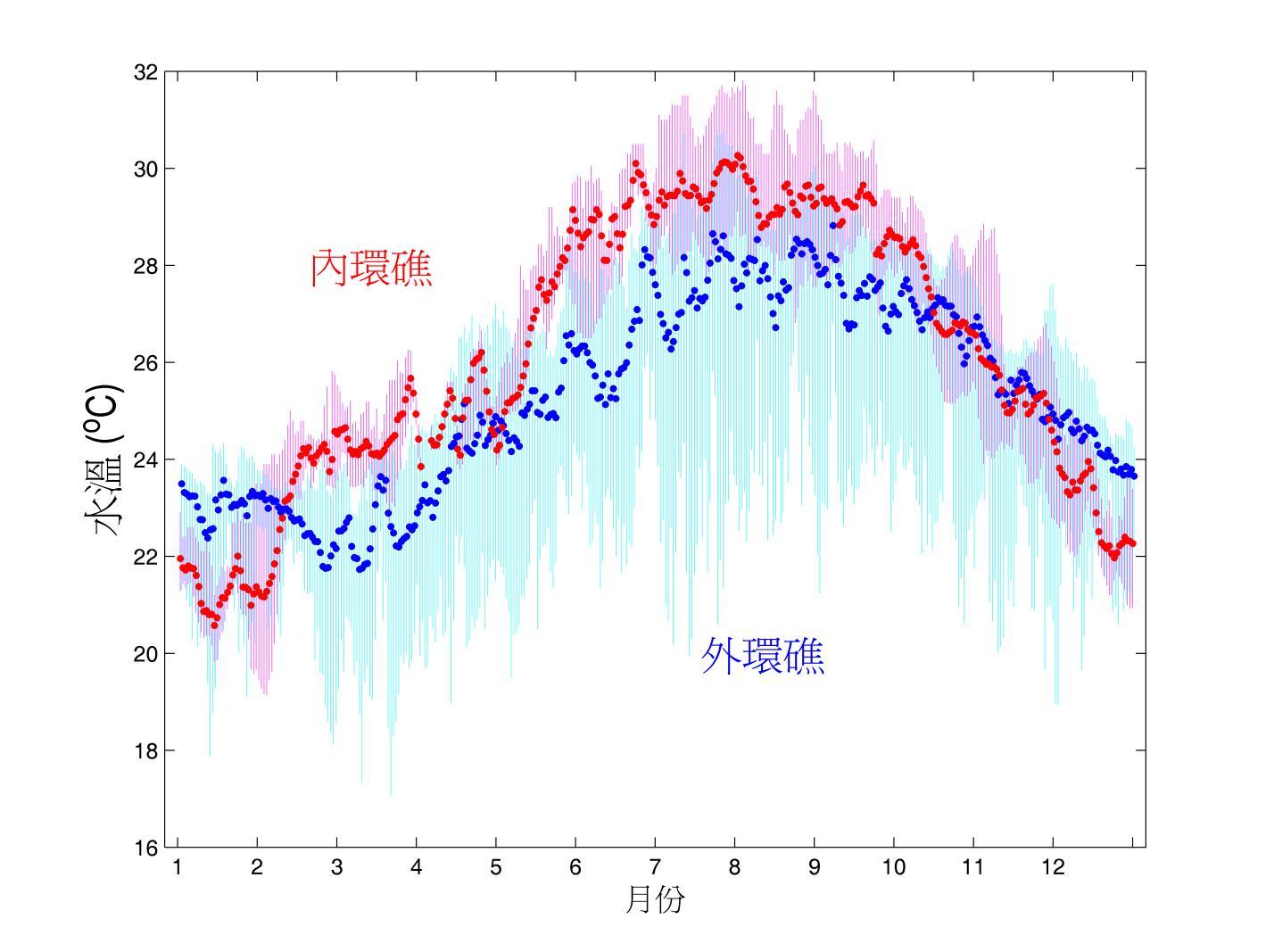
圖5. 東沙海域內環礁與外環礁之水溫比較圖每分鐘觀測一次資料為期三年,點為日平均水溫。
潮位變化在東沙海域環礁內、外相似,因為潮波的波長達上千公里,東沙環礁水位像是一個點。觀測到的最大日潮差150公分,最小日潮差30公分,日潮差的平均值約90公分,日潮差隨農曆朔望有15天的週期(圖6)。調和分析(圖7)結果得知,東沙海域以全日潮為主,主要分潮(振幅)為全日潮O1(27公分)、K1(29公分),半日潮M2(13公分)、S2(5公分)。
Tidal levels are the same in both inner and outer atoll. Since the thousands kilometers tidal wave length, Dongsha Atoll is as a spot in the tidal waves. The largest daily tidal range is 150 cm, and smallest is 90 cm. The changes of tidal levels basically follow the 15 days lunar cycle (Fig. 6). Harmonic analysis (Fig.7) indicated Dongsha area mainly experiences diurnal tide. The tidal components are diurnal O1(27 cm), K1(29 cm) and semi-diurnal tide M2(13 cm)、S2(5 cm).
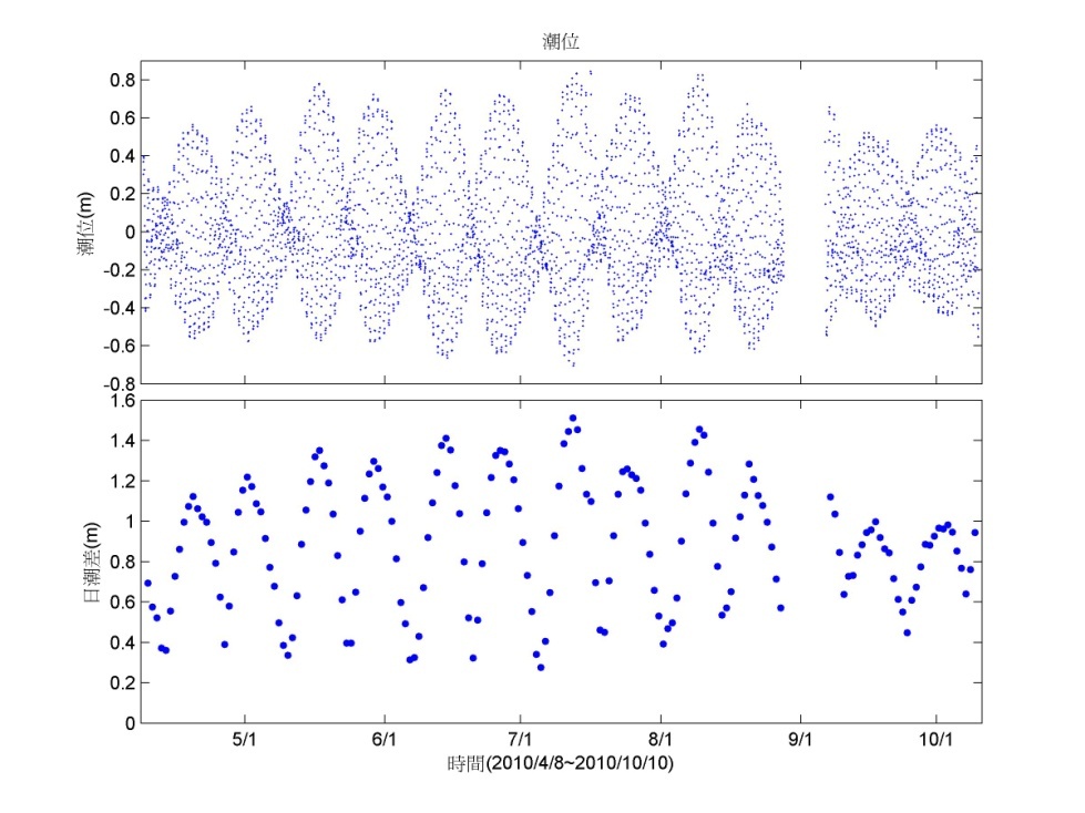
圖6. 東沙潮位與日潮差時序圖。
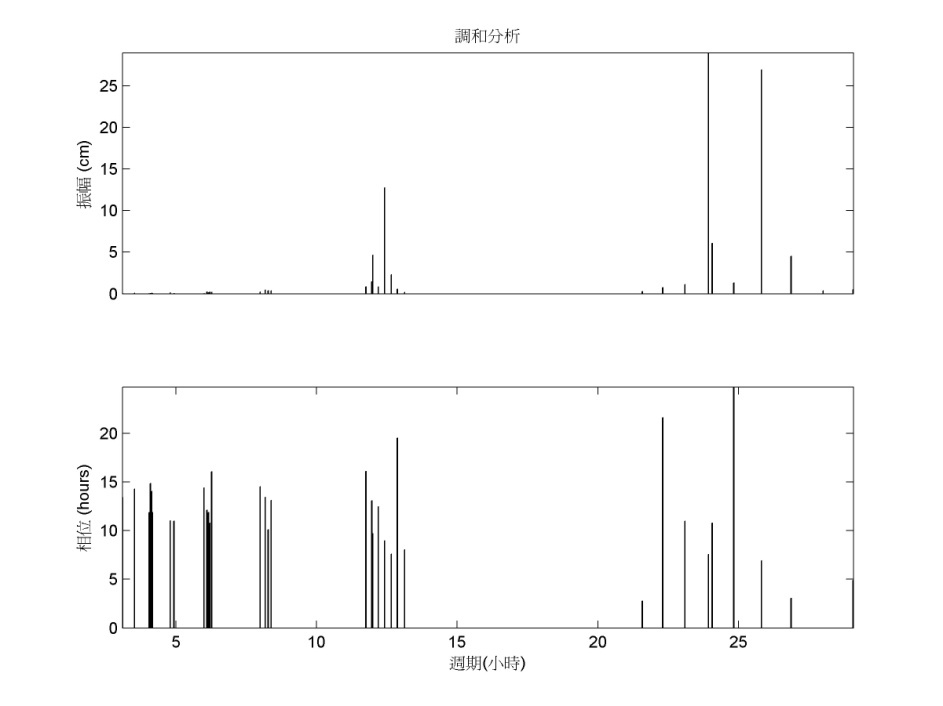
圖7. 東沙水位調和分析之振幅(上)及相位(下)。
海流觀測資料顯示環礁內部流場相對較小,最大海流為34 cm/s,平均約6 cm/s。環礁外流速較強,以環礁外以及靠近南北航道的測站呈現較大的流速,測得最大海流為148 cm/s,平均約24 cm/s,北航道流速平均約21 cm/s,整體上環礁外的海流的強度約為環礁內的4倍。海流調和分析相位的結果可得知,潮流主要由環礁外逆時針經北航道傳遞擴散到環礁內。漲、退潮期間表層流場主要由北航道進出,退潮時段(圖8)海流除了主要由北航道口出去外,同時在南航道有時會出現順時針渦漩的流場。漲潮時段(圖9),南航道除海流較緩外,南航道口的流速分佈在空間上並不平均,較強的流速主要呈現在航道的南側,且環礁內北側與南側海流呈現相反的方向。潮流橢圓(圖10)顯示海流主要是以全日潮為主(K1、O1),半日潮(M2)為輔,潮流橢圓主要受地形影響,橢圓的主軸以平行等深線為主。
Current speed The strongest current speed is 34 cm/s, and 6 cm/s in average in atoll lagoon. The fore reefs and water channels are with higher current speed. The highest current speed of 148 cm/s was recorded near the channels, and 24 cm/s in average. Generally, the current speed is 4 times higher in fore reefs than in lagoon area. Water masses mainly exchange in northern channel. The main current alone the northern reef flat enters the atoll lagoon through the northern channel with anti-clockwise direction when flood tides (Fig 8). Meanwhile, a weaker current occurs in the southern channel with an uneven spatial speed distributions (Fig 9). The stronger current speed is observed at southern side of the southern channel with an opposite direction current at northern side of the channel. Except for the main current goes out from northern channel in ebb tides, clockwise eddies occasionally occur when the currents pass through the southern channel. The tidal ellipses indicate that there are mainly diurnal tides (K1, O1) around Dongsha Atoll, while the semidiurnal tides (M2) occurs occasionally. The ellipses are influenced by topography, and the longer axes are basically follow the bathymetric lines.
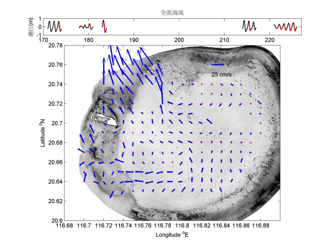
圖8. 退潮時段之海流空間分布棍棒圖。
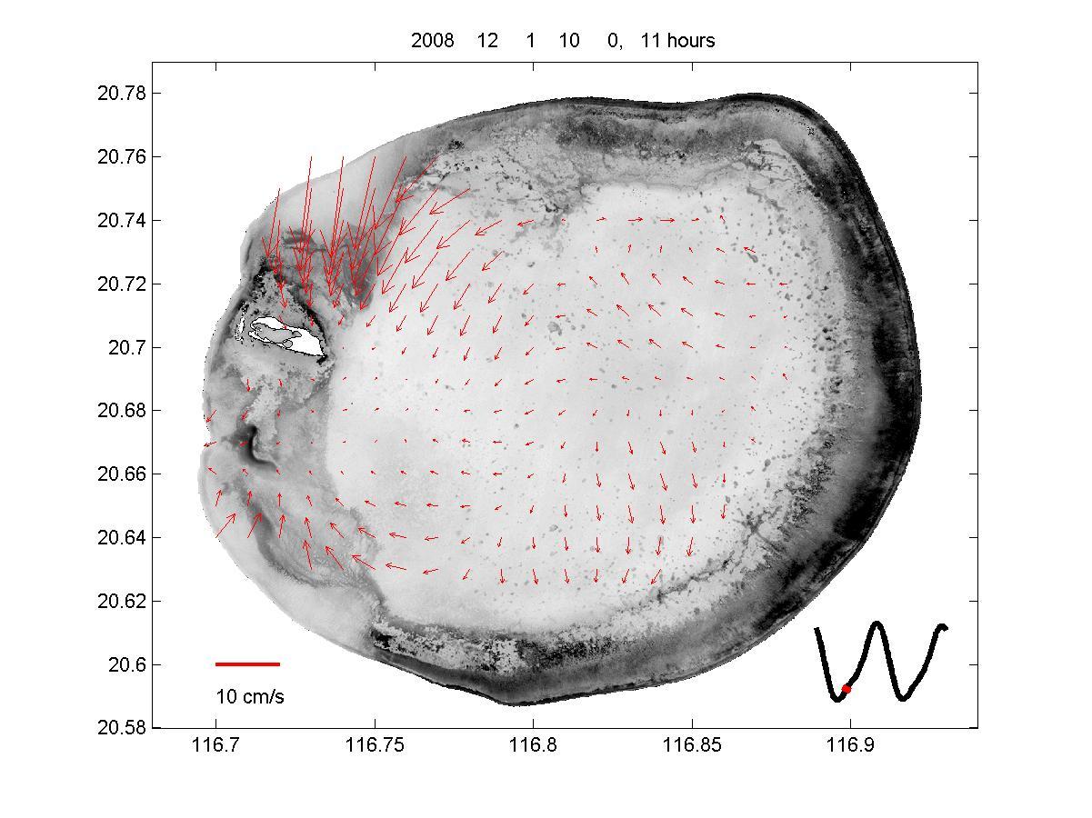
圖9. 漲潮時段之海流空間分布棍棒圖
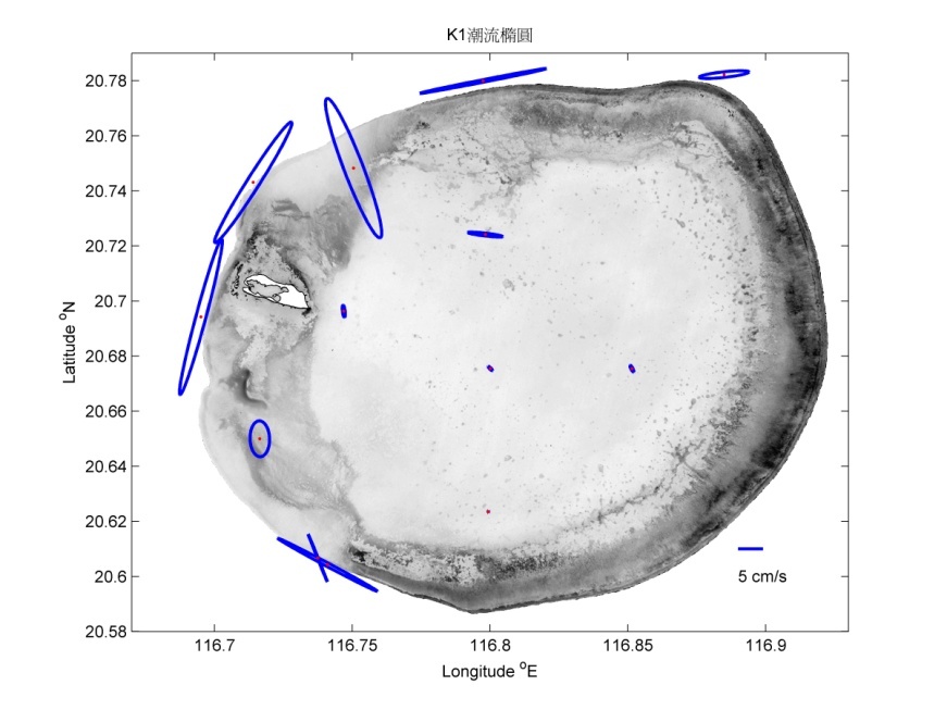
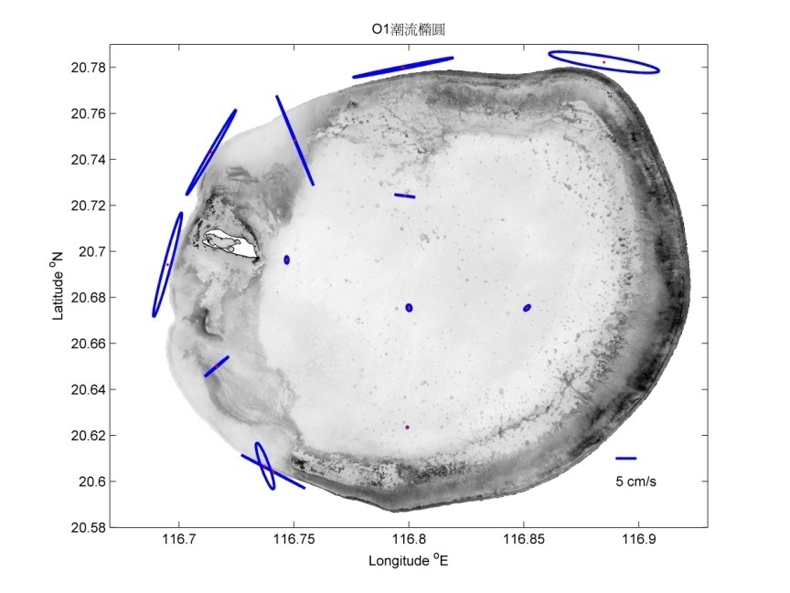
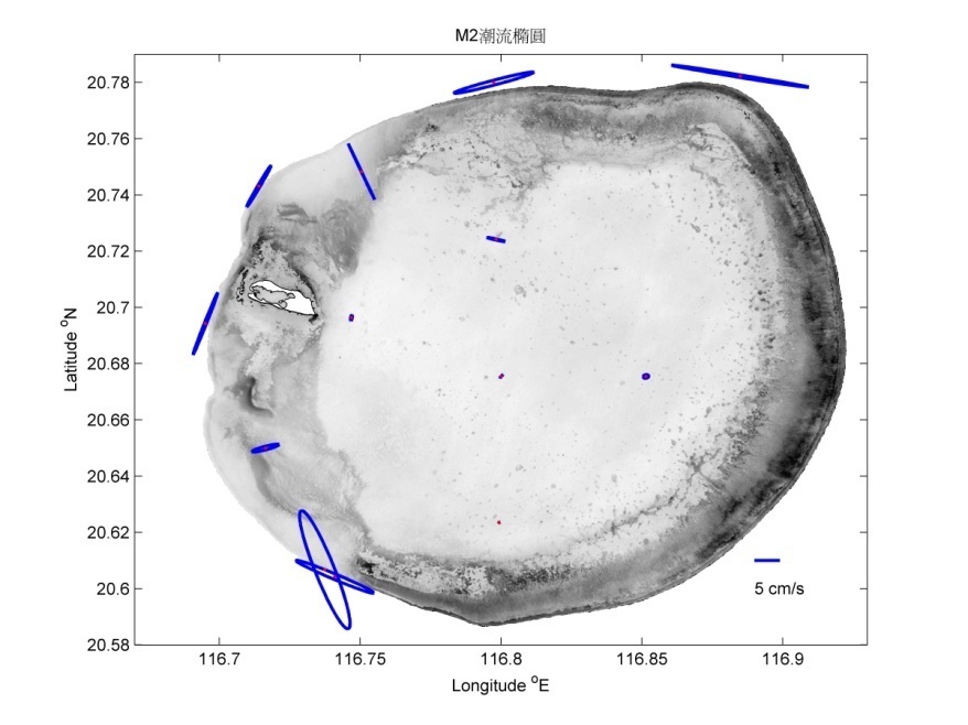
圖10. 各測站全日潮(O1、K1)與半日潮(M2)之潮流橢圓。
波浪週期主要分布在6至10秒,環礁內外相似,表示受到大洋風浪所主導。波高在環礁內較小,約在0.2至1公尺。航道受到東沙島部份遮蔽,最大波高4公尺,平均波高約1公尺。環礁外波高較高,可達5公尺以上,平均波高1至2公尺。冬季東北季風持續維持較大波高,5至9月轉西南季風波能轉弱且有西南湧浪的訊號,7至9月颱風期有較大的波高(圖11)。
Wave periods are 6-10 sec in both inner and outer atoll which indicated the waves are derived by oceanic factors. Wave amplitudes are 0.2-1 m, and are lower in lagoon than in fore reefs. Northern and southern water channels may be protected by Dongsha Island, and have lower wave amplitude than outer atoll. The highest wave amplitude in channels is 4 m and the average is 1m while the highest amplitude in fore reefs is 5 m and 1-2 m in average. Occasional monsoon may enhance the wave amplitude continuously. Swells that generated by southwest monsoons may occur from May to September. Typhoons that usually occur from July to September also enhance the wave amplitude significantly (Fig. 11).
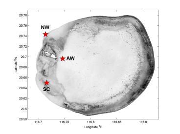
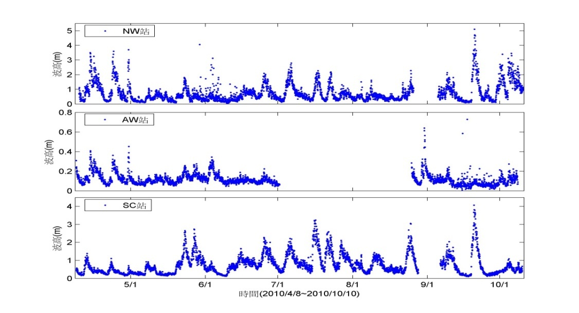
圖11. NW、AW、SC 三站波高資料,觀測時間從2010年4月8日至10月10日。
溫鹽特性基本上與南海水團一致,東沙環礁位於南海北端,為南海水團所包圍。環礁潟湖與島上小潟湖,因受到地形影響而不利於內外海水交換,再加上水體體積不大,使得環礁內海域及小潟湖比外圍之南海海水,更容易受季節與氣候變化影響。觀察東沙環礁潟湖的溫鹽特性(2011年4月、7月、10月)(圖12),4月時與南海表水相符,7月時則溫度升高,10月時則因颱風外圍環流影響而降雨造成鹽度下降。東沙島上小潟湖對氣溫與降雨的反應更敏感,其溫度(18.4~36.7℃)較環礁潟湖平均高約1至5℃,而鹽度範圍則為32.4~34.4psu,其不同季節變化亦較環礁潟湖大,除降雨的效應外,亦有可能是因為島上排放的淡水所導致的結果。
Temperature-Salinity Diagram in outer atoll had similar trend with South China Sea water mass especially in April, 2011. Water temperature was increased both in July and October, 2011. The salinity was lower in October because of the precipitation from Typhoon. The atoll lagoon and island lagoon were with low water exchange rate because of their semi-closed topography. Additionally, with the smaller amounts of water mass in island lagoon, the temperature-salinity diagram were influenced by weather conditions easily. The temperature range in island lagoon was 18.4-36.7˚C, which was 1-5 ˚C higher than atoll lagoon. Salinity range in island lagoon was 32.4-34.4psu, and with higher fluctuation than atoll lagoon as well. Besides the precipitation, the drainage from Dongsha Island could be a reason for the salinity fluctuations in island lagoon.
(Fig. 12)
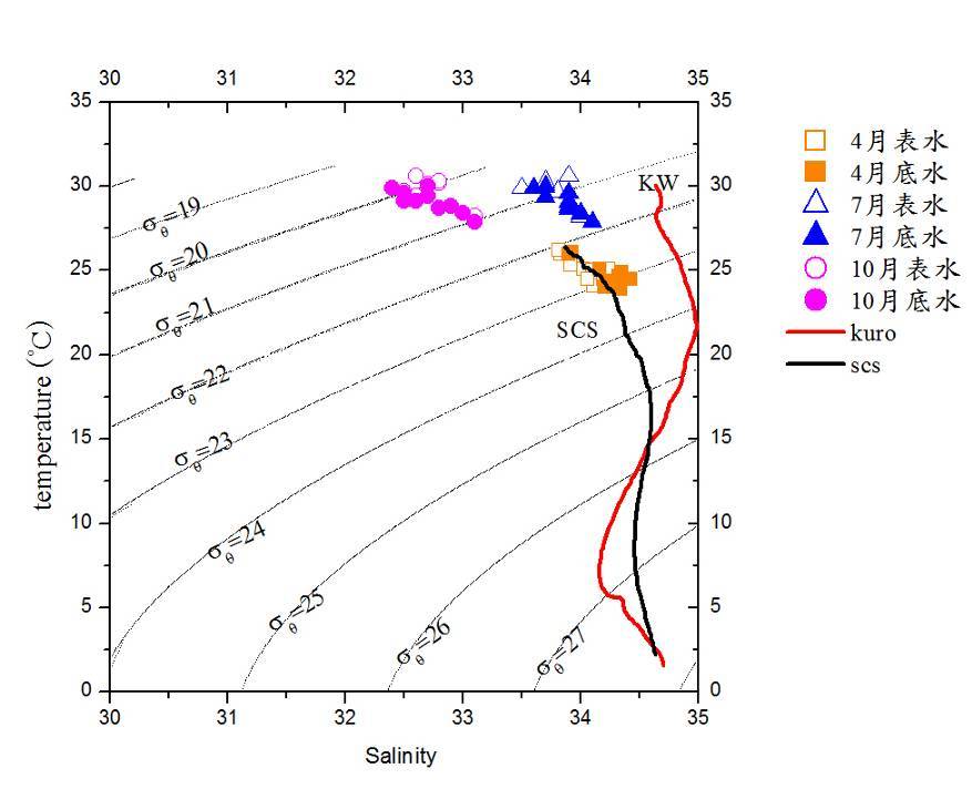
圖12. 東沙環礁潟湖的溫度、鹽度分布圖,並與南海水團(South China Sea, SCS)和黑潮水團(Kuroshio, kuro)比較。
南海內波為全球海域少見的內波頻繁且振幅特大的地區,由近年研究顯示南海內波於大潮前後較易發生,內波垂直振幅超過150公尺,週期約10分鐘至數小時,內波產生強勁的流場可達1.5 m/s且引起次表層溫度變化約5至6℃。內波產生源於呂宋海峽,正壓潮與呂宋海峽海底山脊作用,產生內潮,向南海及太平洋兩側行進。呂宋海峽產生之內潮於行經南海海盆時,依當時潮流強度不同,可能呈現不同程度的非線性特徵,波長縮短且振幅加大。在地球自轉的效應及非線性效應的作用下,內潮波形變陡,逐漸演變成內孤立波。當內潮及內波傳播至接近東沙環礁附近大陸斜坡時,因非線性效應與地形作用強化成巨大振幅的非線性孤立內波。在東沙環礁外緣之觀測研究結果顯示,南海內波會舉升深層高營養鹽之海水至表層,造成東沙附近海域葉綠素濃度之大幅增高,且內波舉升之冷水,有助東沙外環礁珊瑚群聚生態 (圖13)。
South China Sea waters are with high frequency and the most energetic internal waves (IWs) among the global ocean. The IWs are usually found before or after spring tides. The amplitude may over 150 m, and periods are around 10 min to hours. Wave speed may approximate 1.5 m/s and IWs may also induce water temperature fluctuation of 5-6°C in deeper water. The IWs may perform nonlinear wave characteristics such as shorten waves and higher amplitude when pass through South China Sea basin with different wave strengths (Fig.13).
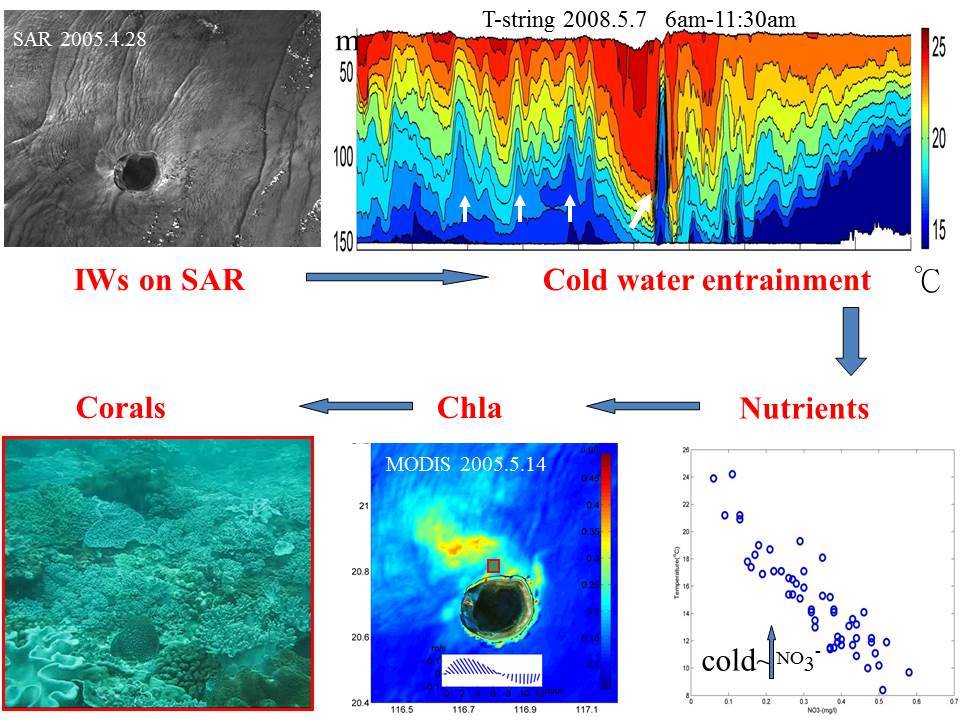
圖13. 南海內波會舉升深層高營養鹽之海水至表層,造成東沙附近海域葉綠素濃度之大幅增高,且內波舉升之冷水,有助東沙外環礁珊瑚群聚生態。


